Search This Blog

Showing posts with label SH1. Show all posts

01 June 2023

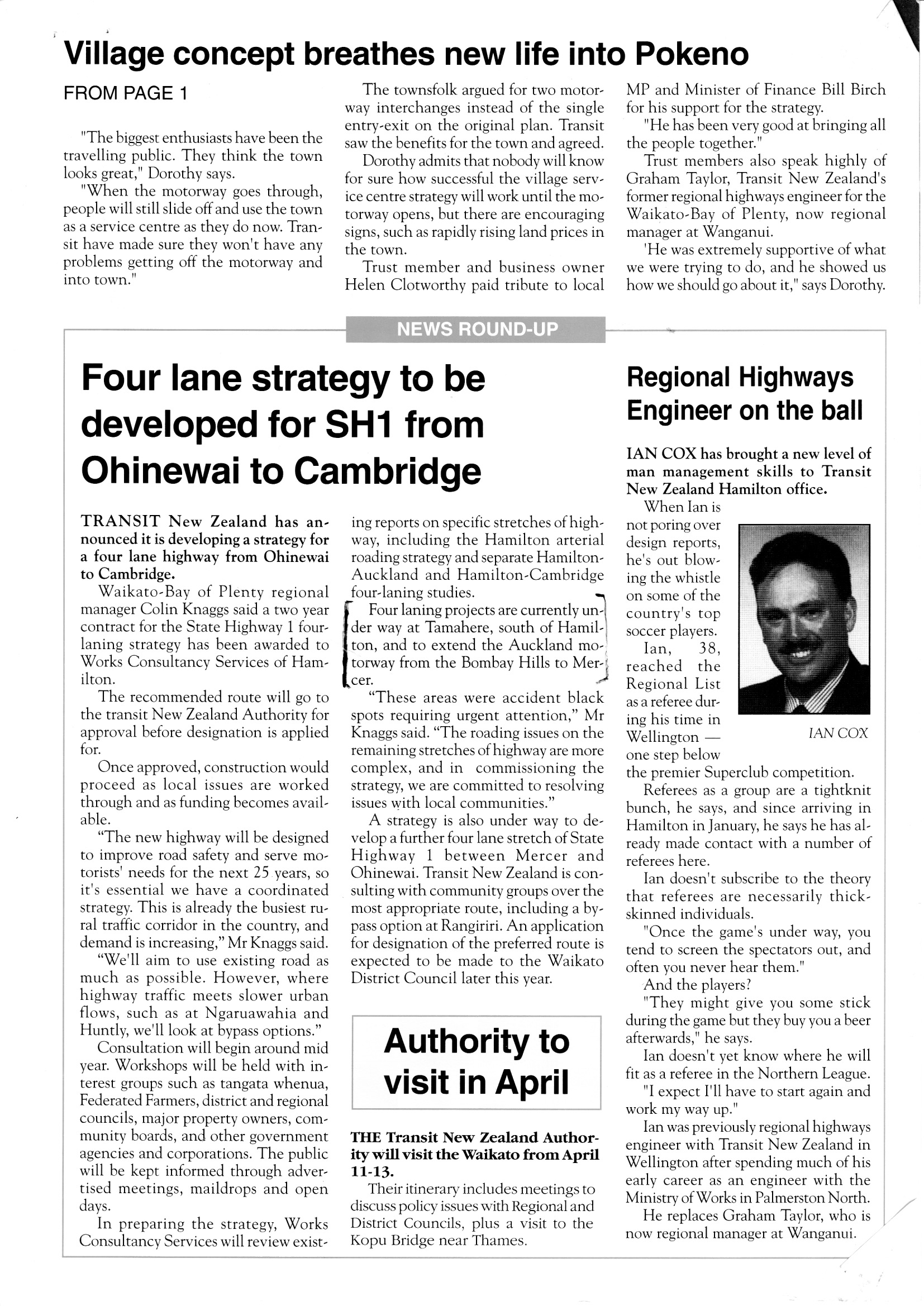
Connections March 1995 - Pokeno Bypass and announcement of strategy for Waikato Expressway


Pokeno Bypass

Pokeno Bypass

Waikato Expressway

Waikato project update

In this edition of Connections, the Hamilton regional office newsletter, the focus as in the national newsletter, is on the Pokeno Bypass, with over two pages dedicated to how the project will enable the town to be upgraded and grow.  The other key point in this issue is the strategy for a "four lane highway from Ohinewai to Cambridge" which would later be known as the Waikato Expressway (completed at the end of 2022!).  The thought at the time was to use as much existing road as possible, but that bypasses would be looked at for Ngaruawahia and Huntly.  The report noted four-laning was already underway at Tamahere between Hamilton and Cambridge, and projects south of the Bombay Hills (including the Pokeno Bypass) that extend the motorway to Mercer (because both locations were accident blackspots).  A separate strategy is being developed between Mercer and Ohinewai.  

Finally, a whole page dedicated to a long list of projects of various scale across Waikato, ranging from the three projects on SH1 between the Bombay Hills and Cambridge, along with a large number of mostly safety oriented realignment projects across the region, plus finishing the sealing of SH25 Coromandel, Fairy Springs Road 4-laning in Rotorua.  This all emphasised the focus of funding at the time on small to medium sized safety oriented projects.

31 May 2023

In Transit March 1995 - No 61 - focus on bypasses


In Transit March 1995 No 61

Bypasses

Urlich Hill, Tar Hill, Catlins

Auckland south-eastern arterial etc

Bypasses

This edition ran a feature article on bypasses, highlighting the construction of the Pokeno bypass on SH1 being tendered (which would become essentially the top stage of the Waikato Expressway). The key point being how bypassing the town enabled reconstruction of its main road to suit local traffic and visitors, whereas some towns feared bypasses would mean the end of passing trade, Pokeno was welcoming it. 

The article continues to make some points about different towns and the conditions that determine whether or not a bypass might proceed such as whether existing roads are largely used vs. a new corridor (as the latter is more expensive it is less likely to be funded).  Levin and Stratford were cited as towns where it was too expensive to build a bypass as a new road would be needed.  Levin curiously was noted that 75% of southbound traffic and 66% of northbound traffic stops in Levin - given the current project to extend the Otaki Expressway to north of Levin (bypassing it), conditions have clearly changed somewhat.   Hikurangi and Mangonui in Northland have both benefited from bypasses, and it was noted that relocating SH1 away from downtown Hamilton had enabled the main street to be made more pedestrian friendly.  This reportedly increased city centre shopping.  

Wanganui was noted as having a motorway designation for a bypass, but this was considered unrealistic given traffic volumes, so a bypass close to the proposed route is proposed.  Ashburton was an interesting case study, in that SH1 was relocated onto a parallel road away from the town centre, but development occurred on the new route. This is considered suboptimal, because it simply means the new route becomes congested as well.  Transit NZ focused on bypasses providing safer and more efficient traffic flow.

Size of towns was important in considering bypasses, with Hamilton, Tauranga and Palmerston North having the main arterial running through them, able to stand on their own, but smaller towns regard through traffic as a lifeblood.  Timaru was noted as upgrading its main shopping street once its bypass is completed. Temuka likewise.  In Dunedin, SH88 was relocated away from Anzac Square/Dunedin Railway Station to make it more attractive for tourists, which was paid for fully by Dunedin City Council because it was a marginal disadvantage to motorists on the state highway. Progress was noted on designing bypasses for Motueka and Stoke, despite funding being considered marginal at this time. Finally, the bypass of Orewa (which ultimately became the Northern Gateway toll road) was noted as being as issue, because residents were concerned about the effect of the link road into Orewa (plus the original bypass designation was shelved, because Orewa's development mean the bypass would run between developments.

Other projects

  • Urlich Hill realignment in Northland was approved (a 1km project)
  • Mangaiti Hill deviation south of Tokoroa on SH1 had started (a 6 km project)
  • Funding for sealing 11km of the Catlins Road had been approved, with a remaining 32km left to be sealed.
  • Transit NZ has approved funding for Auckland City Council's South-Eastern Arterial project (with plans for it to be linked to Mangere Bridge in due course)
  • Strategy underway to ease congestion on Auckland's Northern corridor, by relieving bottlenecks on approaches to the Harbour Bridge, and developing a priority lane between Onewa Rd and Constellation Drive to encourage bus use and high occupancy vehicles. This would ultimately lead to construction of the Victoria Park Tunnel and the Northern Busway (although at the time the plan was for widening the Victoria Park viaduct). Note the expectation at the time was that the busway would be a high-occupancy vehicle lane.

30 May 2023

Transnews - Dunedin regional newsletter of Transit NZ March 1995 - Haast Pass sealing


Wanaka to Haast Road Sealed

Transnews March 1995 regional update

Transnews was the Dunedin Regional Office newsletter, this issue highlights:
  • Completion of the sealing of SH6 Haast Pass, comprising the last 5.5km of SH6 that was unsealed.  Noting effort taken to make it a two-lane route.
  • Completion of flood repairs in Southland and Otago
  • Safety improvements on SH6 in Invercargill
  • Design contract awarded for the Fairfield Motorway extension in Dunedin, which would eventually bypass Fairfield and connect the Green Island section of Dunedin Southern Motorway to the Mosgiel realignment.
  • Tenders called to realign SH1 between Hillgrove and Katie
  • Sealing contract awarded to complete sealing the last 16km SH87 between Middlemarch and Kokonga (also part of the strategy to seal all state highways.

20 May 2023

Connections August 1994


Connections August 1994

Connections August 1994

The Hamilton Regional Office published a newsletter called Connections, this is the first edition. It summarises progress on a range of projects in the Waikato region. Of historical note are:
  • Upgrades to SH25 around the Coromandel Peninsula including completing the sealing of the highway!
  • Three major SH1 projects that all comprised part of the Waikato Expressway and were the first stages of the expressway.
Other projects listed include realignments at Mangaiti Hill south of Tokoroa, Tuahu realignment south of Atiamuri (both on SH1), Chinaman's Hill realignment and Te Kawa Crossroads on SH3, and the Whakahora Deviation on SH27.  Altogether it highlights how many relatively small, but high value projects were being advanced with Benefit Cost Ratios of 5 and above in the region, primarily because they would reduce serious accidents.

SH25

In 1994, there was concern about the need to make the only highway around the Coromandel Peninsula safer and more resilient. A key part of this is sealing the section from Whitianga to Coromandel to enable a sustainable and attractive tourist route.  

SH1

The term "Waikato Expressway" had not been coined yet, but Transit NZ had already made a strategic decision to plan for a four-lane highway between Auckland and Cambridge.  The three projects mentioned are under construction, out to tender and under design respectively:
  • Tamahere Deviation: 3.5km of expressway south of Hamilton at the intersection with Airport Road, justified due to the poor accident record, but showed some considerable foresight to build the first segment of expressway in Waikato.  Note the construction cost of only $9 million.
  • Mangatawhiri Bridge Realignment: This segment south of Pokeno eliminated a sharp and narrow section of highway (now Pioneer Rd).  Noting that it took 2.5 years of loading on the ground due to the soft soils, which would prove to be an issue for other segments of road in this area, and was a short four-lane segment designed to connect with..
  • Pokeno Bypass: Hard to believe now, but in 1994 SH1 went through Pokeno.  The new 4km bypass connecting directly with the (then) recently opened Bombay Hills Interchange would, with the Mangatawhiri project, effectively extend the expressway south to Mercer,  As with other early segments, the accident rate in Pokeno, plus travel time and fuel savings made this a highly efficient project to advance.


22 April 2023

Ngauranga Interchange

It's 1982, and the National Roads Board (an arm of the Ministry of Works and Development (MOWD)) had approved the Ngauranga Interchange. This interchange which opened in 1984, finally linked the Wellington Urban Motorway to SH1 in Ngauranga Gorge, enabling the vastly underutilised capacity of the Urban Motorway to be used, and relieving chronic congestion at the Ngauranga intersection between the Hutt Road and Ngauranga Gorge Road/Centennial Highway (as Ngauranga Gorge's state highway was known). Of course having three lanes each way in Ngauranga Gorge coming to a halt at a traffic light controlled intersection saw significant traffic jams in the AM peak, and likewise in the PM peak traffic backed up south along the Hutt Road. Indeed before the Ngauranga Interchange, the Hutt Road had along much of its length from Ngauranga to Aotea Quay (as SH1) had a tidal flow lane that operated at peak times in the direction of peak flow.  One limitation of the Interchange, which was due to the limitations of the Urban Motorway, is that Cook Strait Rail Ferry (now Interislander) traffic, including heavy vehicles, would have to continue to exit at Ngauranga and use the Hutt Road and Aotea Quay ramps to access the ferry terminal (this is about to be addressed with construction of a new roundabout on Aotea Quay to enable traffic to exit the Urban Motorway at Aotea Quay and reverse to access the Interislander terminal).

This was one of the last major road projects in Wellington carried out by the MOWD before the National Roads Board and Ministry of Works were abolished, replaced by Transit New Zealand (as the combined state highway manager and land transport funding agency) and Works Corporation (which was subsequently privatised), which itself was subject to competition in highway construction as the sector was opened up to mandatory outsourcing.

The Ngauranga Interchange demonstrated some of the best construction and planning the MOWD did in its latter years, and has stood the test of time. It permanently relieved the congestion at the Ngauranga intersection, although today the key congestion comes from traffic between the Hutt and the Northern Suburbs/Porirua.  The Interchange itself was originally built with one lane dropping/feeding to and from the Urban Motorway, and the second lane breaking/merging. More recently a fourth lane was added by narrowing the shoulder, northbound from Aotea Quay to Ngauranga, relieving northbound congestion, and the southbound merge extended to enable smoother merging.

The legacy of the Ngauranga Interchange includes several other impacts:

  1. SH1 status was removed from the Hutt Road and its Aotea Quay ramps and shifted to SH1 (but remained on the Aotea Quay motorway ramps and Aotea, Waterloo, Customhouse and Jervois Quays terminating at Taranaki St until the 1990s).
  2. It enabled the Hutt Road/Kaiwharawhara and Ngauranga areas to grow their commercial and retail activities, as the removal of SH1 from that road enabled much easier access to those locations. 
  3. It relieved the waterfront route along Aotea/Waterloo/Customhouse/Jervois Quays, as SH1 traffic was not required to use that route to get to Te Aro or other suburbs.
  4. It saw the limitations of the end of the Urban Motorway at Ghuznee/Vivian St (with one Terrace Tunnel) become obvious, as congestion there and through Te Aro became a regular occurrence.
  5. It gave Wellington one of the most dramatic and beautiful entrances by highway into a capital city anywhere in the world.
Below is a leaflet published by the Government Printer (another government agency privatised subsequently) promoting the Ngauranga Interchange before it was built (apologies for the writing/drawing in parts from school age me)

Ngauranga Interchange publicity leaflet front page
Ngauranga Interchange publicity leaflet page 2

Ngauranga Interchange publicity leaflet page 3

Ngauranga Interchange publicity leaflet page 4

Ngauranga Interchange publicity leaflet page 5

Ngauranga Interchange publicity leaflet page 6